hiking
Tour des Combins
From 690.-/pers
Activity
hiking
Location
Combins massif
Duration
3 to 6 days
Difficulty
medium | difficult
Headcount
1 to 10 people
Activity details
Tour des Combins : A Classic Trek
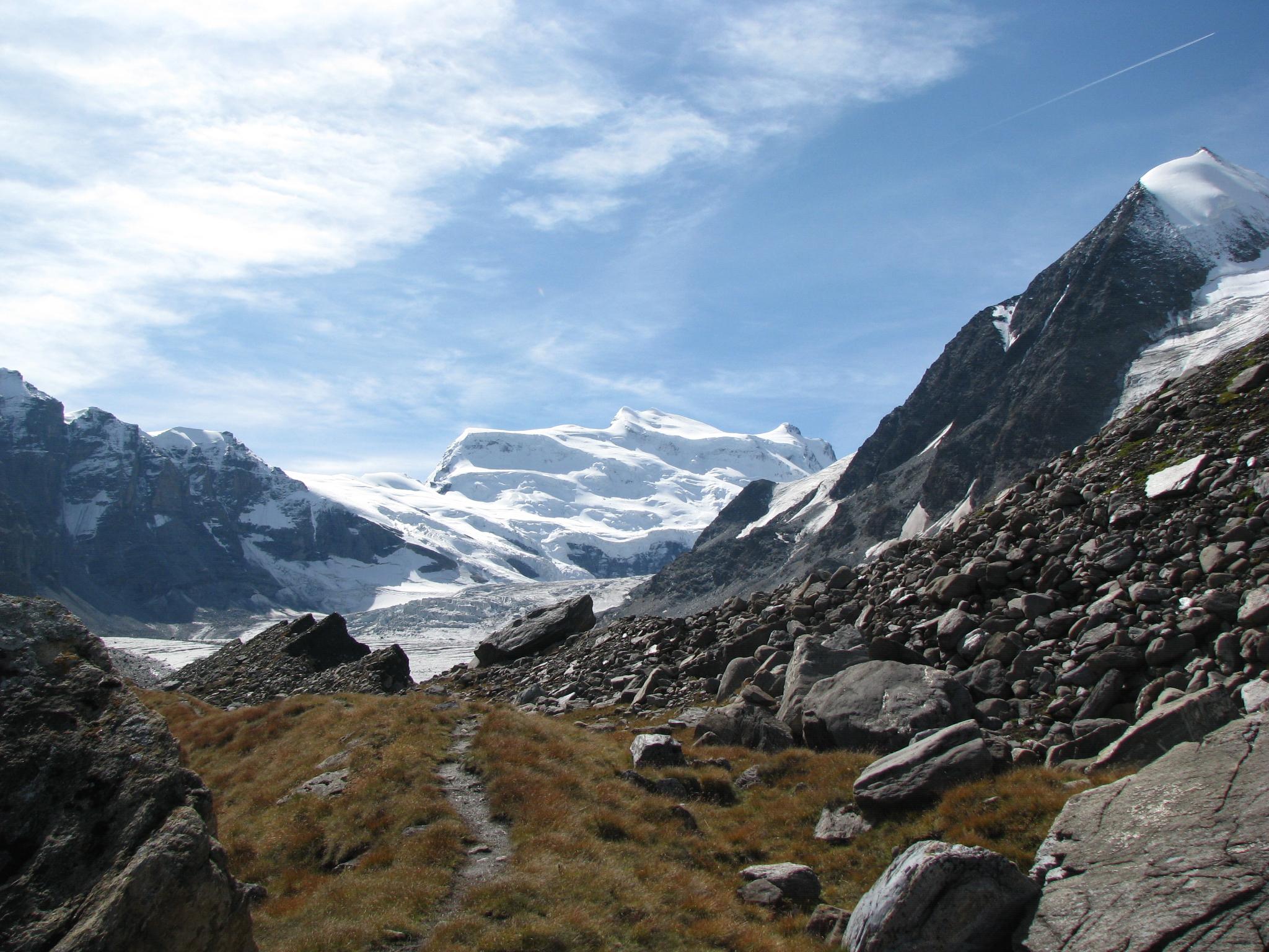
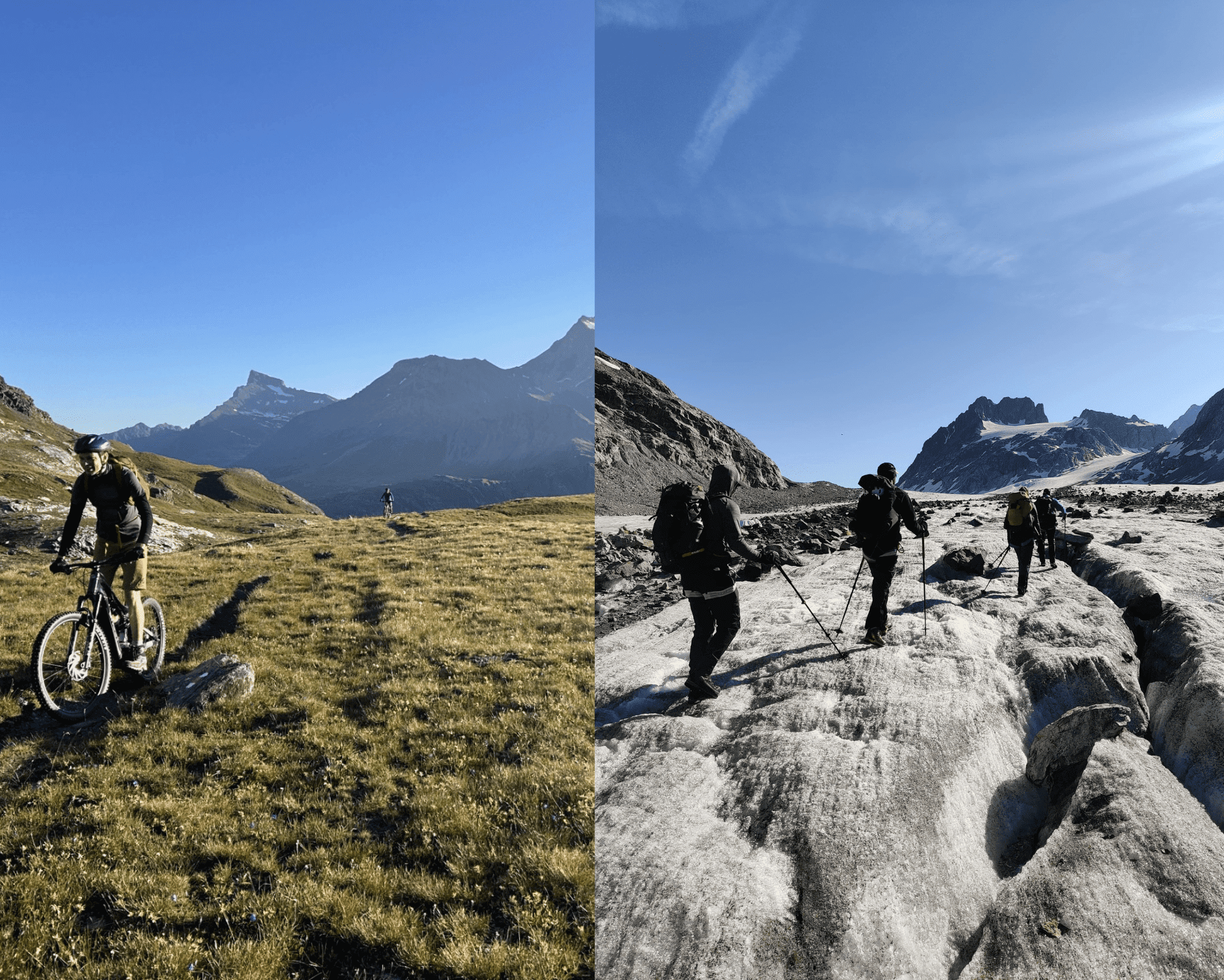
Discover the Tour des Combins, a classic trek that is less frequented than the famous Tour du Mont Blanc. This adventure takes you around the majestic Grand Combin massif (4314m) and its neighboring peaks, crossing the border between Italy and Switzerland.
The Tour des Combins offers multiple options for stage division. You can opt for round-trip summits or choose to shorten certain sections using road transport, making the trek adaptable to your preferences.
The Guides of Verbier offer two itineraries for this tour.
For more information and to discover the detailed itineraries, visit : https://tourdescombins.com/
Highlights
- Breathtaking panoramas
- Diverse terrains
- Regional discovery


pricing
TDC in 6 days –
– 1525.-/person CHF
TDC in 3 days –
– 700.-/person CHF
Included in the price
- Guidance by a mountain leader
- Overnight stays and half-board in mountain huts
Not included in the price
- Costs for required technical equipment
- Lunches (picnic)
- Transportation (taxi or public transport)
Your outing
Itinerary I
Day 1 : Mauvoisin 1841m – Cabane Chanrion 2462m
- Elevation Gain: +950m / -350m
- Distance: 10.7 km
- Duration: Approximately 5 hours of hiking
Departing to the end of the world… You begin your adventure in the upper Val de Bagnes, heading towards the Chanrion hut at nearly 2500 meters.
We start this trek directly on a true mountain trail from Mauvoisin. By road, we access the top of the dam which we cross to reach the right bank of the lake. Then, continuing through a series of galleries and past waterfalls, a good path leads us to the Giétroz Stables, buildings classified as “historical monuments.”
We then cross the picturesque Tsofeirë plateau to reach the Tsofeirë pass, before descending to the Chanrion hut, where a well-deserved arrival awaits you.
Overnight in dormitories at the authentic mountain hut of Chanrion.
Day 2 : Cabane Chanrion 2462m – Champillon 2465m
- Elevation Gain: +1135m / -1170m
- Distance: 22.7 km
- Duration: Approximately 7 hours and 50 minutes of hiking
Crossing into Italy for a change of scenery and a return to less alpine altitudes. A typically Italian evening awaits us!
From Chanrion, we can glimpse the rest of the route. We descend over the harmoniously undulating crests of the pastures to the Grand Charmotane bridge. After a steep initial climb, the slope gradually eases. Through areas of mixed grass and rock, a comfortable trail leads us to the Col de Fenêtre (Fenêtre de Durand). We cross a scree to finally reach the pastures of Thoules.
Here begins the agricultural road leading to the Balme pasture and then to the Conca di By. From there, the trail climbs to join the Ru de By 150 meters higher, which we follow to Néan. We then leave the Ru de By to climb to the Tsa de Champillon and finally reach the Letey Hut.
Day 3 : Cabane Letey 2465 m – Grand Saint-Bernard 2469 m
- Elevation Gain: +1211m / -1184m
- Distance: 20.3 km
- Duration: Approximately 7 hours and 30 minutes of hiking
A day through pastures and forests, discovering typical hamlets of the Aosta Valley, culminating in the arrival at Grand Saint-Bernard, a historical passage known for over 2000 years.
From the Letey Hut, we take a steep trail leading to the Champillon pass. In the background, the imposing trapezoid of the Grand Combin rises, while to the west, the Mont Blanc range unfolds. We then descend to the Menouve valley, up to the Pointier mountain.
We follow the trail that climbs to the Combe Germain pasture, then join the Ru d’Eternod, which we follow west through a beautiful larch forest to reach the Barasson Mountain.
We then take the trail that climbs to the left to join the forest road, which we follow to Plan Puitz. We continue to Cantine de Fonteinte and join the Tour des Combins route to finally reach the Col du Grand Saint-Bernard.
Day 4 : Grand Saint-Bernard 2469 m – Cabane de Mille 2471 m
- Elevation Gain: +1370m / -1350m
- Distance: 25.6 km
- Duration: Approximately 8 hours of hiking
A beautiful stage between mountains and valleys ending at Mont-Brûlé at 2572 m. The Mille Hut is friendly and warm.
From the Col, we descend into the Combe des Morts to pass by the Hospitalet. After the Pierre pasture, a vaulted stable dating from 1707, we skirt modern achievements with the road tunnel entrance and the Toules dam on its left bank. We continue our path through Bourg-Saint-Pierre, the terminus of this stage, discovering the Lorette chapel, the Creux du Mâ, Boveire d’en bas, the Coeur, and Erra. The easy trail crosses pastures, offering a panoramic view of the entire Entremont Valley.
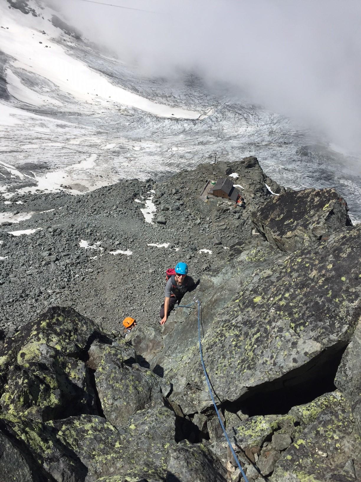
We finally reach the Col de Mille, where the magnificent Mille Hut awaits us. This guarded hut, with 59 places, will charm you with its incomparable panorama and warm atmosphere.
Day 5 : Cabane de Mille 2471 m – Cabane Brunet 2104 m via Mont Rogneux
- Elevation Gain: +580m / -940m
- Distance: 8.9 km
- Duration: Approximately 5 hours of hiking
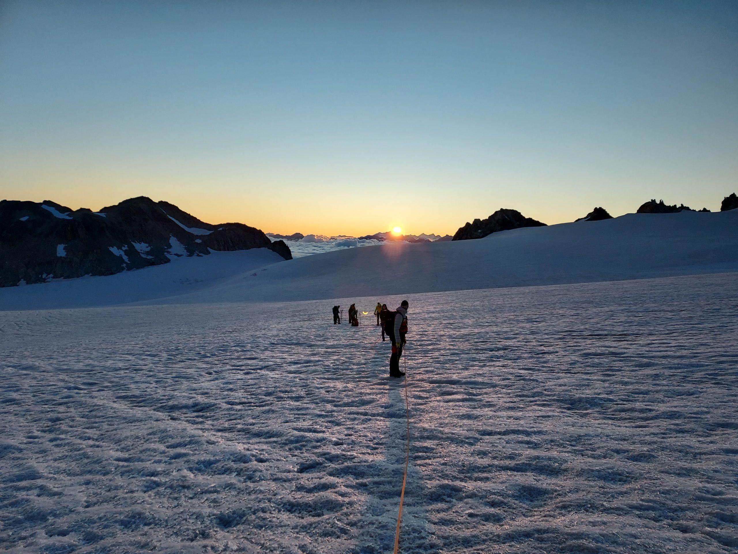
We start the ascent of Mont Rogneux, reaching 3082m, where we can enjoy an exceptional panorama of the Combin massif. Then, we descend through the pastures to reach the Brunet Hut, located at 2104 m.
6ème jour : Cabane Brunet 2104 m – Mauvoisin 1841 m
- Elevation Gain: +1030m / -1290m
- Distance: 13.3 km
- Duration: Approximately 5 hours and 50 minutes of hiking
For our final stage, we will experience an apotheosis under the Grand Combin. We will pass by the Panossière Hut before climbing to the Otanes pass. Leaving behind the Combin massif, we reach Mauvoisin to conclude this great hike.
Price: Based on a group of 4 people: 1245.- per person
________________________
Itinerary II
Day 1 : Bourg-St-Pierre – Cabane de Mille
- Elevation Gain: +1150m / -250m
- Distance: 12.6 km
- Duration: Approximately 4 hours and 20 minutes of hiking
We begin our adventure in Bourg-Saint-Pierre, the most important town crossed by the TDC. Before heading to the heights, we take the time to visit its historical monuments: the Saint-Charles Bridge (Charlemagne), the ancient bell tower, the Roman milestone, and the well-preserved old houses. We then pass by the Lorette Chapel, Creux du Mâ, Boveire d’en bas, Le Coeur, and Erra. The trail crosses pastures, offering beautiful views of the Entremont Valley. Our day ends at the Col de Mille, where the magnificent Mille Hut awaits us. This guarded hut, with 59 places, boasts an incomparable panorama.
Day 2 : Cabane de Mille – Cabane Panossière
- Elevation Gain: +1420m / -505m
- Distance: 14.4 km
- Duration: Approximately 5 hours and 30 minutes of hiking
Past the Col de Mille, we enter the territory of the commune of Bagnes, one of the largest in Switzerland (282 km²). Ahead of us to the north stretches the Verbier station up to the foot of Pierre Avoi. We hike northeast to reach Treutse at 2092m, with an unobstructed view of the surrounding villages.
Heading east, we follow a path through bilberries and arolla pines, leading us to the Brunet Hut. Then, heading southeast, the trail alternates between ascents and descents, leading us to the Sery footbridge over a narrow gorge. Without major difficulties, we reach the place called “la Maye.”
A steep zigzag ascent takes us to a large footbridge of nearly 200 meters spanning the waters and the Corbassière glacier. In less than an hour on an easy trail, we arrive at the François Xavier-Bagnoud Hut in Panossière.
Day 3 : Panossière – Mauvoisin
- Elevation Gain: +300m / -1100m
- Distance: 6.5 km
- Duration: Approximately 3 hours of hiking
After skirting the moraine on the right bank of the Corbassière glacier, we begin a short but steep ascent to the Col des Otanes, peaking at 2870m, the highest point of the TDC. From there, the panorama is fascinating, offering a spectacular view of this rock and ice cirque dominated by the Grand Combin, one of the most beautiful sites in the Alps.
In an hour’s descent, we reach Tseumette, a grassy saddle where we can admire the peaks of Mont-Pleureur and Ruinette. In the valley below, we see the imposing 250-meter-high concrete wall of the highest arch dam in Europe. We continue our descent to Mauvoisin, marking the end of our adventure.
Price: Based on a group of 4 people: 550.- per person
Price
From 690.-/pers
All rights reserved – Les Guides de verbier – 2025
Website created by pomilo.fr